Kentucky Ain’t Just About Horses… Mammoth Cave

When most of us think of Kentucky, we think of horses, blue grass, hills and bourban… but, did you know that underneath Kentucky is the world’s largest cave?  Actually, there are two cave systems in Kentucky.  With the ground consisting mostly of limestone, which easily erodes, underground rivers formed and carved out hundreds of miles of tunnels that curve and turn, labyrinth style, like a bowl of spaghetti.

During the war of 1812, saltpeter was mined from Mammoth Cave as a key ingredient for gunpowder.

Geologists say that there could still be another 600 miles of tunnels yet to be discovered.

There are several ranger led tours and we took the historic tour.  It was interesting seeing hundreds of names placed on the walls and ceilings by the early guest in the cave.  Some were carved, some were put up with the soot from candles and lanterns.

There is also a self-guided tour called the Discovery Tour that takes about 30 minutes, that allows you to go at your own pace. 

We really enjoyed our trip to Mammoth Cave with Bill’s sister Tolley and her hubby Charlie.  When we come this way again, there will be more to see in this cave because it sure does live up to its name.

Inside an Historic Hot Springs Bathhouse

The Fordyce Bathhouse is run by the National Park Service.  It is free.  When we walked in, a ranger behind the desk said “Welcome to the Fordyce”.  They directed us to a short film and then we went on a free ranger guided tour.

One of the most beautiful aspects of this Victorian Renaissance style building is the stained glass work.

Not just in the windows, but also in the ceiling.

This is the packing room.  Here attendants would run the towels under the tap, ring them out and place them on patients as they lay down on these beds.

Private bathing rooms, with men separated from women, allowed the patient to immerse themselves in the Hot Springs’ healing waters.

I more therapy was needed, this room provided an alternating hot and cold therapy, a “pin” shower where water was directed at specific parts of the anatomy, an enema table, and…

 … an electro-shock therapy tub.  Here, copper electrodes connected to the controls on the wall would actually be immersed in the bath. Our guide described how the patient would have to grab onto the rim of the tub.

Our ranger guide described how after therapy, guests would relax in the sun room.  In this room, men and women still were segregated, with men on one side with a billiards table and women on the other with a piano.  This room was also called the Music Room.

Those afflicted with paralysis were lowered into their bath on this bed and then there was a rail system in the ceiling where the bed could be wheeled out to the Sun Room.

There was also a large fully equipped gym. 

Tickets for a number of baths could be bought at a time and then used during their stay.

A room full of Zander Machines which were an early version of our modern day workout equipment.

A room for all things foot related.  Foot massage, pedicure, corn and bunion treatment.

A women’s Beauty Parlor

And men’s and women’s Massage Rooms.

It was amazing to see how this place worked and how seriously health and healing was regarded in this town at the height of it’s hayday.  Even though some of the treatments might now be considered ghoulish, it was obvious to us that people came here to relax and rejuvenate their mind, body and spirit.

Hot Springs National Park and The Gangster Museum

Way long ago, explorer Ferdinand de Soto searched for the Fountain of Youth and it is said that he found it here, in Hot Springs, Arkansas.  Then it was claimed by the French, and bought by the US in the Louisiana Purchase.  Soon, explorers were sent out to explore the newly bought territory and the 140 degree springs were tagged as a hot spot.

Here, 47 springs bring up water, heated by the Earth, that originally seeped down through fissures, many, many years ago.  In 1832, the United States made Hot Springs a federal reservation putting the thermal waters under federal protection, and was made a National Park in 1921.

Now, you can drive up to a federal fountain and fill as many bottles as you want with the healing waters.  Or, you might want to bring your travel mug and tea bag for the perfect cup of tea, the water comes out of the fountains at 140 degrees  (see the steam).

A water composition report is posted for you.  We were told at a fountain that the waters are a perfect therapy for arthritis, both taken internally and externally.

A number of wooden bath houses sprung up in the 20’s and Hot Springs was a real wild west town.  Several fires did away with those and eventually Hot Springs progressed to architecturally ornate bath houses along the main street, Central Avenue, creating what is now known as Bathhouse Row.  The Arlington Hotel can be seen in the background here. 

Also known as “Spa City”, this area soon became the place to come to relax and improve one’s health.  Prior to modern medicine, doctors prescribed a list of things for ailments ranging from arthritis to polio.  Behind Bathhouse Row is a series of walking trails called the “Grand Promenade” for exercise and relaxation.

Something else the waters were perfect for was for breweries and distilleries.  Al Capone ran the spirits that were brewed with this water all throughout the country during prohibition.  Even though gambling was illegal in the state of Arkansas, gambling took place in the hotels and night clubs of Hot Springs due to the fact that Mayor Leo McLaughlin enlisted the help of the English Godfather, Owney Madden to bring people to Hot Springs by making it a gambling mecca.

Indeed it did and Hot Springs was where several crime families and individuals came to relax and party.  They may have been killing eachother in other cities, but when they came to Hot Springs, they all got along, until they went back home again and resumed shooting at eachother.  Gambling was finally closed down in Hot Springs in 1967 and it moved to Las Vegas.

We found Hot Springs to be a wonderful place to experience.  The bathhouses are still running and you can go have a spa day, tour the city, hike the trails and commune with the mountains.  There are some great places to enjoy food, poetry and music.

New Mexico’s Petroglyph National Monument

The Visitor’s Center of Petroglyph NM is beautiful.  Although there are no petroglyphs there at the VC, and you need to drive a short way to the sites, which are managed in partnership with the NM State Parks, it is worth the visit.

But the petroglyphs are amazing.  Pecked into the rock with sandstone hammer and chisel by Ancient Puebloans who came from the Chaco Canyon area 400 to 700 years ago.

Except for ancient stories being handed down within Native American Tribes, no one really knows the meaning of these messages, but we thought this one looked like a weasel holding a tennis racquet.

This is a Macaw.  They were brought from Mexico by traders  and were treasured by the ancient tribes. 

If you are ever near Albuquerque, experiencing Petroglyph National Monument in person is will be a special experience.  Wear hiking boots, bring a walking stick, wear sunscreen and a hat and be ready to hike.

The Volcanic State

Something I never knew is before being “The Land of Enchantment”, New Mexico was called “The Volcano State”.  It has more dormant volcanoes than any other state in our country.  In fact, there is a fault line running diagonally across the state delineating the flatter eastern portion from the more scenic western portion.

We visited El Malpais (called that by early Spanish Explorers meaning “The Bad Lands”) National Monument near Grants, NM.  It was a little confusing because our GPS took us to the Administration Offices in town first.  The park abuts the I-40 Interstate and can be reached by two different exits.  The western exit, 81 takes you to the western portion of the park which has long hikes and is less scenic.  The eastern exit 89 goes to the more scenic portions of the park where you have 360 degree views of volcanic fields and can walk on lava flows.  Well, we took the wrong exit and it was getting late, so we missed the more scenic portion of the park.

We did, however get to pick out extinct volcanoes in the skyline.

Here you can see lava flows from 2-3000 years ago all over between the mesas.

Plant matter is reclaiming the territory.

The stark contrast is somewhat surprising to find and wondrous to see…

…and part of what gives western New Mexico it’s uncommon beauty.

AZ’s Sunset Crater Volcano and Walnut Canyon National Monuments

Our plans changed as we realized that our trip to Payson would include 4 hours of driving.  We opted to do it another time.  Instead, we headed for Flagstaff where three National Monuments lie: Wupatki, Sunset Crater Volcano and Walnut Canyon.  We made it to two of these.

The geology of Arizona has been puzzling me for a while now.  When rockhounding with my friend Jamie in Wickenburg, south of here, we met a rock shop owner who mentioned that there had been volcanoes all around, hence contributing to the wonderfully colorful jaspers and agates all over AZ.

When we were in Oregon, I understood how the volcanic activity in Oregon created its colorful hard jaspers and agates, and its obsidian there, due to Oregon’s location on the Ring of Fire.  The Ring of Fire refers to the volcanic area all around the Pacific (tectonic) Plate, which basically is underneath the entire Pacific Ocean, its edges at the US west coast and east coast of Eurasia (including Japan).  Tectonic plates are constantly moving and floating, and when there is a large movement, an earthquake occurs such as the recent one that caused the tsunami that hit Japan.  Plate tectonic action causes cracks in the Earth’s crust that allows molten lava to escape, thereby creating volcanoes.

What puzzled me was that Arizona is way too far inland to be part of the Ring of Fire.  So, when visiting Arizona’s Sunset Crater Volcano National Monument yesterday, I had the opportunity to ask a knowledgeable Ranger.  What I learned was that northern Arizona is actually on a small (comparatively) floating plate that moves in a back and forth rotation.  For the past six million years, volcanic activity has created over 600 hills and mountains in the Flagstaff area, called the San Francisco Volcanic Field.  In fact, Humphrey’s Peak, the highest point in Arizona, now currently snow-capped, was once a volcano. The Ranger told us that as we drive along I-40, every hill and mountain we see was either a volcano or created by lava flow.

Sunset Crater Volcano is the most recent, approximately 1000 years old, and spewed lava for 20 years, which is average for volcanoes.  The layer of ash still can be seen all around, making it look like there was a recent forest fire.  Gigantic fields of black lava, frozen in time can be seen along the drive through the park.  The sunset name comes from the reddish colored cinder cone surrounding the crater at the top. 

The process of breaking lava down into soil is transpiring now by fungus called lichen.  The ash that was thrown into the air while the volcano was active brought rain and the ash that landed on the ground added nutrients to the soil.  Ancient Puebloans settled here to farm this soil, with abundant rainfall, creating the village sites we now know as Wupatki and Walnut Canyon.  By 1180 AD thousands farmed the area, by 1250, when the volcano had quieted, the Ancient Puebloans had moved on.  Their descendants live today and the Hopi, the Zuni and the Navajo.

Walnut Canyon was a thrill to see.  It is a huge mile deep grey/tan rocked canyon dotted with yucca, pines and cactus, with Walnut Creek running through the bottom.  The inhabitants there farmed on the rimtop and made dwellings on the cliffs using clay blocks and covering them with a gold colored clay and used wooden beams, unique to these people.  They came here because of the fertile soil created by Sunset Crater’s volcanic ash.  There is a walking trail that takes about an hour and goes past some of the dwellings down to the bottom, and another walking trail that goes along the rim of the canyon.  We walked along the rim and saw ancient dwellings along both sides of the canyon.  Imagining how it once was, it must have been amazing to live there. 

The meteor crater, where we are staying happened about 50,000 years ago, and Sunset Volcano erupted about 1000 years ago.  Wish I had my camera to share, hopefully it will be back home soon…

…. and Me without a Camera

On Saturday, our time was up in Quartzsite and we headed north on I-17 towards Flagstaff.  Weather was unpredictable, as it usually is around Flagstaff this time of year, and we hit several rain squalls.  We arrived at our destination in Camp Verde, in the beautiful Verde Valley, south of Flagstaff (where the interstate was closed), and immediately found ourselves hit by sleet and snow.  What a treat to see the mountains of Arizona capped in snow, it felt like Colorado.  Not a treat to set up and unhook our rig in the mess, LOL.  But, we finally managed and got settled.  The next day, we drove the 20 mins to Sedona to see a rare sight, the red rocks of Sedona covered in snow.  You just don’t see that every day… and me without a camera…

The next day, we saw Montezuma’s Castle, an ancient site of cliff dwellings by early Native Americans.  It was a lovely park, with a path lined with Sycamore trees running alongside Beaver Creek.  The dwelling was called Montezuma’s Castle by the first Spanish explorers, who thought they were the same peoples as they saw further south, even though Montezuma never came that far north.  The dwellings resembled the ones in Mesa Verde, only more remote.  They were a sight to see, and… me without a camera, yet again…

Today’s drive through Flagstaff was great.  It’s warmed up, but still a little snow alongside the highway and we turned off I-17 onto 40 East and headed toward Winslow.  Gorgeous snow-capped Humphrey’s Peak proudly stood as the highest point in AZ all in it’s early spring regalia.  Wish I had gotten a picture to share, but yeah, it was me, without a camera… again.

We’re settled into our site here just east of Winslow, AZ…. at the site of the best preserved meteor crater on Earth.  And… me without a camera!  Just got word that my camera is being shipped and I hope to be re-united very soon.  We’ll be staying here for a week.

Saguaro National Park – West

Visiting Saguaro National Park, we were immediately impressed with the vast beauty of the Sonoran Desert.  Saguaro is broken up into two different sections, west and east (of Tucson).

The Saguaro Cacti (pronounced sa-wah-ro) are so beautiful.  No two are alike.

They start as tiny black seeds.  They can grow up to 50 feet tall.  It can take up to 75 years to grow a side arm and they can live to be 150 years old.

Then we took a walk up the Signal Hill Trail.  See the hill up ahead?  There are some special rocks on that hill…

Petroglyphs!

So intriguing.

We felt like we stepped through a time portal.

So we took the trail back to the present moment.

Enjoy the Video!

Casa Grande Ruins National Monument

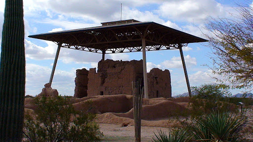
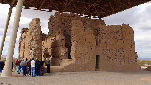
Casa Grande was built at the rise of the first known civilization in Arizona.  The people who built it are called Hohokam, which is a name used to identify the people who first lived in the Sonoran Desert.  This structure, the big house, was completed by 1350 CE (AD) and was found to be abandoned by a group of missionaries by 1694 CE (AD).  The word Ho-ho-kahm was used by the Pima Indians about its inhabitants, their ancestors, meaning “all-gone” or “all used up”.  (they probably meant the resources here, which is why many ancient Indian tribes abandoned a place and moved on to build anew)

This was called Casa Grande by those missionaries for a reason.  It was constructed from 3,000 of Caliche, a concrete-like mix of sand, clay and calcium carbonate (limestone).  The mud was formed in courses to build a low wall that was four feet thick at the base.

Then, small trees were felled and floated down the nearby Gila River and stood up, anchored in the walls to form vertical supports.  Saguaro branches, called ribs, were then laid perpendicularly across the ribs, and covered perpendicularly again with reeds.  All these layers were covered by a final coating of Caliche mud.

In 1932 a ramada called the Olmsted Shelter was built to shelter the ruins from weathering.

The building was built so that it’s four sides face the four cardinal directions, holes were made in the walls to line up with the sun and moon at certain times of the year that would indicate to them the time to plant, harvest and to give thanks and celebrate.

The Hohokam people dug an intricate series of canals with interlocking gates that brought water from the Gila River into the village for irrigation and for this hunter/gatherer society.

This is how the settlement was set up.  Compounds were a collection of spaces surrounded by walls that served as living areas and religious and other daily activities.  Notice that there was an oval shaped ball court near the center of the community.

This is what it looks like now.  It was probably used for ball games similar to the ones the Aztecs played.  (ball courts have been found as far north as northern Arizona)

This is what this ball court may have looked like in the day of the Hohokam.

These mounds are near the ball court and are in the location of the city center.  The platform mound may have served a religious function and/or been a location of social hierarchy and ancestral status.  Meaning, the reigning family, and religious leaders, held rituals on top of the mound, and when they were gone (for one reason or another), they were laid on top and the earth was mounded up over them making another level higher, where the next leaders would be.

  It was a very intriguing place to be…

… and it was another dog-friendly place…

…where Angie was glad she could come with us…

 … and politely waited her turn in line to see.


Guadalupe Mountains and Carlsbad Caverns National Parks

Yesterday morning we woke to a beautiful Tex-Mex sunrise…

…and headed north toward the Guadalupe Mountains.

 The prominent peak in the center is Guadalupe’s El Capitan.  It is named for the Capitan Reef.

40 million years ago, in the Permian Period, there was a three lobed sea here.  Where the waves broke on the shore, a reef was created.  That is what formed the sturdy weather resistant rock that has allowed the Guadalupe Mountains to be what they are. 

 Sea fossils abound here.

 There is great diversity in these mountains.  There are three zones, a desert zone on the floor at the base of the mountains, a riparian zone at the canyon bottoms with streams and springs, and a mountain zone with trees and conifers that you would see in Colorado. Species of plants and animals that could not survive in the desert may find refuge in the highlands, and vice-versa.

Then we moved on to Carlsbad Caverns, about a half hour north just across the New Mexico border.

Entrance fees were free for the day, to commemorate Martin Luther King, Jr. Day.  We rode down a 752 foot elevator in one minute to get to the cave.  We stepped out into another world.

Or should I say… underworld.

It was one of the most incredible experiences we have had yet.

Difficult to describe, yet the experience was so powerful.

I was able to take photos and footage with natural light and night vision.  We didn’t think to bring flashlights, LOL.  I kept bumping into Bill.  The path around is paved and is good walking.  There are sturdy handrails on either side and believe me, you use them.

Hard to believe that such a world exists underneath this unassuming landscape.

Here’s the video… enjoy!

This morning’s beautiful Tex-Mex sunrise.

Today, we are on to Deming, New Mexico.